Your guide to volcanoes in Iceland
16. ágúst 2022
Your guide to volcanoes in Iceland
16. ágúst 2022
It’s all kicking off again! There’s a great deal of excitement surrounding the renewed volcanic activity on Iceland’s Reykjanes Peninsula. Just a short drive from the centre of Reykjavik and the international airport, the eruption at Fagradalsfjall in 2021 caused a rumpus around the world. As Fagradalsfjall’s original volcanic activity died away, new fissures opened up in the area in August 2022. Once again, our attention has turned to the peninsula, where the ‘tourist eruptions’ are easily accessed. While fearsome and beautiful to behold, spewing rivers of molten lava, Fagradalsfjall holds relatively little danger to cautious visitors and the local population.
In contrast, the volcanoes sitting under the ice caps of southern Iceland are much more explosive as fire and water don’t mix! These Icelandic volcanoes have created havoc over the centuries. Their impact has been felt in mainland Europe and beyond as the 2010 Eyjafjallajökull eruption famously demonstrated. Currently, the volcanoes that lie in this area are not active, although Katla could erupt any day soon. Even as these volcanoes lie dormant, a trip to south Iceland should not be missed. The landscapes are majestic and bleakly beautiful. Take one of the volcano tours of Iceland and be prepared to be awed.
How many volcanoes are there in Iceland?
Iceland came into existence when the North American and Eurasian plates spread apart, starting around 30 million years ago. At the boundary, plumes of extremely hot rock push up through the Earth’s mantle, erupting molten magma, building Iceland and bringing about the active volcanoes Iceland is famous for. There are around 130 volcanoes on the island, the vast majority of them dormant or extinct.
How many active volcanoes are in Iceland?
In geological terms, volcanoes are classified as active, dormant, or extinct. Active volcanoes have a recent history of eruptions and could easily erupt again. Dormant volcanoes have not erupted for a long time but could possibly reawaken at a future date. Extinct volcanoes are not expected to erupt again. More than 30 volcanoes are considered active or dormant in Iceland, and 18 of them have erupted since the year 900.
In recent years, there has been thrilling volcanic activity in Iceland that has captured the world’s imagination. The most famous - or infamous - of all is Eyjafjallajökull, its spreading ash cloud grounding flights across Europe. A handful of volcanoes still erupt regularly, including Hekla, Grímsvötn in Vatnajökull Glacier, and Katla in Mýrdalsjökull Glacier. These are exciting times for volcanologists… and for anyone who loves a bit of drama and a good show!
Is there a volcano near Reykjavik?
You bet. The recent volcanic activity on the Reykjanes Peninsula, located between the international airport and the capital has been sweetly convenient for those flying in on a short visit to Iceland. And it has continued to wow us since 2021. Here’s what’s been going on.
Mt. Fagradalsfjall active volcano
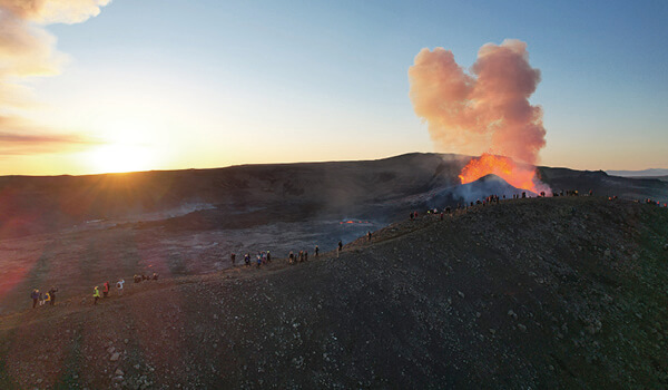
Fagradalsfjall, less than an hour’s drive from Reykjavik, lay dormant for centuries, making it hard to imagine the sleeping giant on the Reykjanes Peninsula ever waking from its long slumber … until February 2021 that is. It all started with a series of earthquakes rumbling on the peninsula. Over the next three weeks, there were thousands and thousands of tremors, some large, some small - some vocal enough to cause sleeplessness on the peninsula and as far as the city centre. The earthquakes, seismologists observed, had been caused by magma below Fagradalsfjall pushing up through the Earth’s crust. Would the rising mass reach the Earth’s surface? Would the magma erupt? No-one was sure. The world watched and held its breath.
Then on the evening of the 19th of March, after three days of quiet, locals observed a strange glow in the sky: a fissure had opened up in the Geldingadalir Valley. The eruption was small, far from settlements and looked relatively harmless.
The “tourist eruption”
This is what Icelanders call a small eruption that’s easily accessed and is safe to observe from a relatively close distance. Fagradalsfjall fitted the definition and put on a fantastic show for locals and tourists alike. People flocked to the peninsula to watch the red-hot lava spurting from the crater like a boiling cauldron. Gleaming molten rivers ran off the slope and spread across the lava fields in fiery veins. It was a spectacular sight.
A new eruption
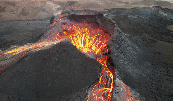
After six months of volcanic activity, the eruptions came to an end. Then on the 3rd of August 2022, after a series of more earthquakes, new fissures opened up and Fagradalsfjall once again started to erupt magma close to the old site. What’s exciting is you can currently observe the active volcano. Remember to follow the advice: park in designated car parks if you have a rental; stick to the paths and don’t attempt to walk on the lava from the 2021 eruption - it’s still hot! Importantly, don’t visit the volcano in adverse weather conditions. Seek out up-to-date official advice, or better still go with an experienced guide. As the characteristics of this latest eruption are similar to the original Fagradalsfjall explosion, experts believe the lava flows could last about six months. The window of opportunity is still open.
• See our “Volcano hike with guidance tour to the active volcano”
More of Iceland’s recent eruptions
Eyjafjallajökull

Eyjafjallajökull: the bad boy of Iceland - notorious, fearsome, magnificent. After its eruption in 2010, air travel in parts of Europe came to a standstill. Eyjafjallajökull sure knew how to cause havoc thousands of miles away. Ironically, It was a relatively small eruption; it just came with unfavourable ashfall.
Unlike Fagradalsfjall, Eyjafjallajökull caused havoc both in Iceland and abroad. In March 2010, it started spewing molten lava in an uninhabited area of south Iceland after lying dormant for 180 years. On the 14th of April, renewed volcanic activity caused massive flooding; 800 people had to be evacuated. Still the ‘bad boy’ continued to make its presence felt. Shooting several kilometres of volcanic ash into the atmosphere, the ash halted flights across northwest Europe and left air travellers stranded.
Just an hour and a half from Reykjavik you can visit the town of Hvolsvöllur with its Visitor Centre. It focuses on the story of a neighbouring farm that was destroyed by lava, ash and flood water. If you’re taking a tour of the south coast, the ice cap covering the volcano is visible from the Ring Road on clear days. It’s an area of raw beauty where the ice field drops away towards the coast.
Nowadays, Eyjafjallajökull - meaning ‘Island Mountain Glacier’ - is once again fast asleep and is not expected to erupt again for centuries. Instead neighbouring Katla is the one to watch …
• See our “South Coast & Eyjafjallajökull - small group tour”
Katla
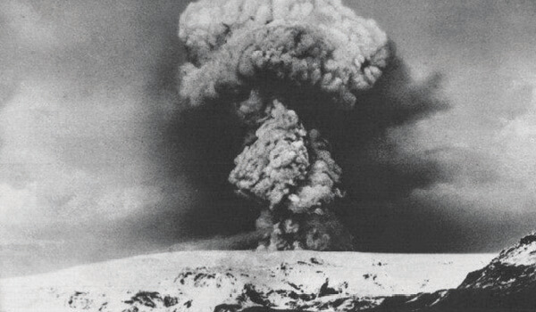
‘You ain’t seen anything yet,’ former president Olafur Ragnar Grimsson famously remarked when comparing Katla to Eyjafjallajökull - not a boast you want to hear when you consider the damage Eyjafjallajökull caused in 2010. Katla is partially hidden under Mýrdalsjökull, a large ice cap located north of Vik on Iceland’s south coast. Katla - The Kettle - has a long history of volcanic activity. It has erupted five times since 1721 with an average gap of around sixty years between each explosion. It hasn’t erupted since 1918 with Icelanders very aware it’s long overdue. They are bracing themselves as a new eruption could be catastrophic. There is some good news, however: geologists believe the Eyjafjallajökull eruption of 2010 may have dissipated the magma pressure of Katla somewhat.
You can see the ice field of Mýrdalsjökull from the Ring Road as long as the weather’s clear. It’s a magnificent sight on sunlit days as you skirt it on the Ring Road, passing much-loved landmarks such as the Dyrhólaey Peninsula with its large rock arch, the black sands of Reynisfjara and the pretty coastal village of Vik. Hiking to the rim of Katla is only for hardcore climbers. At 1,512m, it’s a challenging climb through unforgiving terrain, although one of incredible raw beauty. The caldera of the volcano is 10km in diameter and partially hidden by the glacier with a thick covering of ice. Most of us are content to observe the ice-cap with its fearsome and majestic volcanic mountain from afar.
Skaftáreldar
In Icelandic, Skaftáreldar means ‘Skaftár Fires’. It takes its name from the River Skaftár where lava from the eruption flowed down through the river valley. Outside of Iceland, Skaftáreldar is known as the Laki eruption - somewhat inaccurately - as Mount Laki has long been extinct. Instead, dozens of craters and vents in the Lakagígar fissure - part of the larger Grímsvötn volcanic system - exploded in an event lasting around eight months.
We have to go back into the mists of time for the last Skaftáreldar eruption in Lakagígar. The first ash clouds appeared on the 8th June, 1783 and the eruptions continued until February 1784. The volcano spewed deadly toxic ashes and gases across the land. Lava fountains were estimated to have reached heights between 800 and 1,400m. The craters churned an unimaginable 42 billion tons of basalt lava that travelled up to 40km. The effects of the eruption were felt much further away, however. The volcanic event was devastating: between a fifth and a quarter of Iceland’s population died. Acid rain destroyed crops, animals perished and famine ensued. In fact, the impact of the eruption was felt far beyond the shores of the north Atlantic island. Millions of people died globally because of Skaftáreldar; famine spread to Europe while India and North Africa experienced droughts. Overall, the ‘Fires of Skaftár’ lay claim to Iceland’s deadliest volcanic eruption in modern history. It turns out the bad boy of Eyjafjallajökull is small fry in comparison.
If you want to experience the lunar landscapes of Skaftáreldar, you can hire a four-wheel drive (not for the faint-hearted) or join a tour. The Lakagígar craters stretch for an incredible 25km in a harsh but strangely beautiful landscape of red and black lava fields, southwest of the stunning Vatnajökull National Park.
Fimmvörðuháls
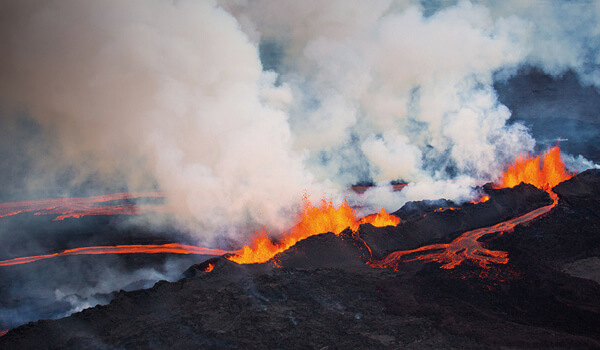
Almost everyone recognises the name Eyjafjallajökull - even if they can’t pronounce it. Fewer have heard of Fimmvörðuháls, a smaller eruption that preceded its infamous neighbour. On the 20th of March, 2010, a half-kilometre fissure opened up, going on to form two craters between the ice-caps of Eyjafjallajökull and Mýrdalsjökull in south Iceland, not far from Þórsmörk. The new craters were christened Móði and Magni after the sons of Thor. A beautiful ‘tourist eruption’, it attracted the attention of people all over the world with its awesome displays of fire.
Nowadays, the 25km Fimmvörðuháls hike snakes through heart-soaring landscapes of deep canyons, waterfalls, fast-flowing waters, rock-strewn and moss-covered terrains and through lava fields where snow can’t lie in places as the rock is still warm from the volcanic activity. It’s a hike that requires a high level of fitness and experience of challenging mountain terrain.
• See our “Laugavegur & Fimmvörðuháls hiking tour”
Mt. Hekla
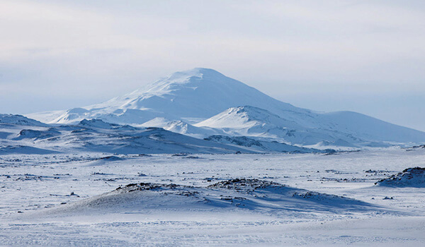
Mount Hekla lays claim to the most active volcano in Iceland. It has erupted more than 20 times since the year 874 and a number of times in the 20th century. The last eruption occurred in 2000. Like Fimmvörðuháls, the Hekla eruptions are generally picturesque ‘tourist eruptions’ but the volcano, giving very little warning, is prone to unexpected activity.
Hekla is part of a 25km-long volcanic ridge. Located in southern Iceland, the beautiful snow-capped mountain soars above replanted forest. You’re more likely to find Hekla shrouded in clouds - quite appropriately, given the name translates as ‘The Short Hooded Cloak’. As with many Icelandic landmarks, Hekla is associated with dark tales: Cistercian monks claimed it was the gateway to hell, while legend holds that witches gather on the volcano for Easter.
You can hike through the dramatic landscapes of Hekla, walking through ice, lava and volcanic ash, or book an off-road 4-by-4 tour. Alternatively, experience the volcano from the comfort of the Hekla Centre on the Landvegur road (check openings), telling you everything you need to know about this unpredictable volcano.
Grímsvötn
Iceland’s most active volcano, Grímsvötn is located at the heart of Vatnajökull glacier. The volcano erupts roughly 10 times a century - a bit of an ‘overachiever’ in volcanic terms. Its most recent eruption in 2011 made its presence felt tens of kilometres away with its 15 to 20km-high ash plumes. Grímsvötn’s caldera actually forms a huge lake, filled with melted glacial water from the huge ice cap surrounding it. It’s something of an oddity, even in Iceland. But while Grímsvötn’s eruptions are mostly tucked under the ice - never displaying picturesque flows of molten lava - they cause immense floods when the caldera over-fills. Then, water bursts out from under the glacier and floods the sands below. If you’re driving past the vast sands of south Iceland, nestled by huge glaciers, notice the long, high and sturdy bridges over what often seem like rather innocent streams. These little streams turn into epic waterways from melted glacier water for just that reason. So, you see that Iceland’s old tagline as the ‘Land of Fire and Ice’ is quite apt.
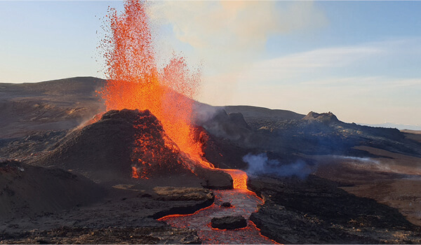
For those of us who live outside of Iceland the ground beneath our feet can appear inanimate - solid and unchanging. In Iceland, there’s a constant reminder the rocks beneath our feet are volatile. They are constantly transforming the terrain across Iceland. Visiting these beautiful and ethereal landscapes, we see hot geysers explode into the air. We see how molten rocks - pushed up from the hot mantle of the Earth - flow as rivers, then harden into unearthly lava fields. We admire conical or ‘table-top’ volcanic mountains, great calderas and marvel at the otherworldly rock formations created by Iceland’s volcanoes. Come and see Iceland’s volcanoes and gaze upon great basalt columns like organ pipes, strangely rounded lava’ bombs’ and ‘pahoehoe’- lava whose surface preserves ripples as memories of it’s liquid origin.
Geologically, Iceland is one of the most exciting places on planet Earth. Start planning the trip of a lifetime and book volcano tours in Iceland.
Áhugaverðar ferðir
Blogg
Fáðu innblástur! Upplýsingar og góð ráð, áhugaverðir áfangastaðir, skemmtilegar staðreyndar og margt fleira. Bloggið okkar er á ensku en það er stórskemmtilegt engu að síður!
The Silver Circle of West Iceland - Your Guide
You’ve heard of the Golden Circle, but here’s why you should head to Iceland’s western region to explore the msytical Silver Circle tour route.
Lesa bloggYour guide to volcanoes in Iceland
16. ágúst 2022
Your guide to volcanoes in Iceland
16. ágúst 2022
It’s all kicking off again! There’s a great deal of excitement surrounding the renewed volcanic activity on Iceland’s Reykjanes Peninsula. Just a short drive from the centre of Reykjavik and the international airport, the eruption at Fagradalsfjall in 2021 caused a rumpus around the world. As Fagradalsfjall’s original volcanic activity died away, new fissures opened up in the area in August 2022. Once again, our attention has turned to the peninsula, where the ‘tourist eruptions’ are easily accessed. While fearsome and beautiful to behold, spewing rivers of molten lava, Fagradalsfjall holds relatively little danger to cautious visitors and the local population.
In contrast, the volcanoes sitting under the ice caps of southern Iceland are much more explosive as fire and water don’t mix! These Icelandic volcanoes have created havoc over the centuries. Their impact has been felt in mainland Europe and beyond as the 2010 Eyjafjallajökull eruption famously demonstrated. Currently, the volcanoes that lie in this area are not active, although Katla could erupt any day soon. Even as these volcanoes lie dormant, a trip to south Iceland should not be missed. The landscapes are majestic and bleakly beautiful. Take one of the volcano tours of Iceland and be prepared to be awed.
How many volcanoes are there in Iceland?
Iceland came into existence when the North American and Eurasian plates spread apart, starting around 30 million years ago. At the boundary, plumes of extremely hot rock push up through the Earth’s mantle, erupting molten magma, building Iceland and bringing about the active volcanoes Iceland is famous for. There are around 130 volcanoes on the island, the vast majority of them dormant or extinct.
How many active volcanoes are in Iceland?
In geological terms, volcanoes are classified as active, dormant, or extinct. Active volcanoes have a recent history of eruptions and could easily erupt again. Dormant volcanoes have not erupted for a long time but could possibly reawaken at a future date. Extinct volcanoes are not expected to erupt again. More than 30 volcanoes are considered active or dormant in Iceland, and 18 of them have erupted since the year 900.
In recent years, there has been thrilling volcanic activity in Iceland that has captured the world’s imagination. The most famous - or infamous - of all is Eyjafjallajökull, its spreading ash cloud grounding flights across Europe. A handful of volcanoes still erupt regularly, including Hekla, Grímsvötn in Vatnajökull Glacier, and Katla in Mýrdalsjökull Glacier. These are exciting times for volcanologists… and for anyone who loves a bit of drama and a good show!
Is there a volcano near Reykjavik?
You bet. The recent volcanic activity on the Reykjanes Peninsula, located between the international airport and the capital has been sweetly convenient for those flying in on a short visit to Iceland. And it has continued to wow us since 2021. Here’s what’s been going on.
Mt. Fagradalsfjall active volcano

Fagradalsfjall, less than an hour’s drive from Reykjavik, lay dormant for centuries, making it hard to imagine the sleeping giant on the Reykjanes Peninsula ever waking from its long slumber … until February 2021 that is. It all started with a series of earthquakes rumbling on the peninsula. Over the next three weeks, there were thousands and thousands of tremors, some large, some small - some vocal enough to cause sleeplessness on the peninsula and as far as the city centre. The earthquakes, seismologists observed, had been caused by magma below Fagradalsfjall pushing up through the Earth’s crust. Would the rising mass reach the Earth’s surface? Would the magma erupt? No-one was sure. The world watched and held its breath.
Then on the evening of the 19th of March, after three days of quiet, locals observed a strange glow in the sky: a fissure had opened up in the Geldingadalir Valley. The eruption was small, far from settlements and looked relatively harmless.
The “tourist eruption”
This is what Icelanders call a small eruption that’s easily accessed and is safe to observe from a relatively close distance. Fagradalsfjall fitted the definition and put on a fantastic show for locals and tourists alike. People flocked to the peninsula to watch the red-hot lava spurting from the crater like a boiling cauldron. Gleaming molten rivers ran off the slope and spread across the lava fields in fiery veins. It was a spectacular sight.
A new eruption

After six months of volcanic activity, the eruptions came to an end. Then on the 3rd of August 2022, after a series of more earthquakes, new fissures opened up and Fagradalsfjall once again started to erupt magma close to the old site. What’s exciting is you can currently observe the active volcano. Remember to follow the advice: park in designated car parks if you have a rental; stick to the paths and don’t attempt to walk on the lava from the 2021 eruption - it’s still hot! Importantly, don’t visit the volcano in adverse weather conditions. Seek out up-to-date official advice, or better still go with an experienced guide. As the characteristics of this latest eruption are similar to the original Fagradalsfjall explosion, experts believe the lava flows could last about six months. The window of opportunity is still open.
• See our “Volcano hike with guidance tour to the active volcano”
More of Iceland’s recent eruptions
Eyjafjallajökull

Eyjafjallajökull: the bad boy of Iceland - notorious, fearsome, magnificent. After its eruption in 2010, air travel in parts of Europe came to a standstill. Eyjafjallajökull sure knew how to cause havoc thousands of miles away. Ironically, It was a relatively small eruption; it just came with unfavourable ashfall.
Unlike Fagradalsfjall, Eyjafjallajökull caused havoc both in Iceland and abroad. In March 2010, it started spewing molten lava in an uninhabited area of south Iceland after lying dormant for 180 years. On the 14th of April, renewed volcanic activity caused massive flooding; 800 people had to be evacuated. Still the ‘bad boy’ continued to make its presence felt. Shooting several kilometres of volcanic ash into the atmosphere, the ash halted flights across northwest Europe and left air travellers stranded.
Just an hour and a half from Reykjavik you can visit the town of Hvolsvöllur with its Visitor Centre. It focuses on the story of a neighbouring farm that was destroyed by lava, ash and flood water. If you’re taking a tour of the south coast, the ice cap covering the volcano is visible from the Ring Road on clear days. It’s an area of raw beauty where the ice field drops away towards the coast.
Nowadays, Eyjafjallajökull - meaning ‘Island Mountain Glacier’ - is once again fast asleep and is not expected to erupt again for centuries. Instead neighbouring Katla is the one to watch …
• See our “South Coast & Eyjafjallajökull - small group tour”
Katla

‘You ain’t seen anything yet,’ former president Olafur Ragnar Grimsson famously remarked when comparing Katla to Eyjafjallajökull - not a boast you want to hear when you consider the damage Eyjafjallajökull caused in 2010. Katla is partially hidden under Mýrdalsjökull, a large ice cap located north of Vik on Iceland’s south coast. Katla - The Kettle - has a long history of volcanic activity. It has erupted five times since 1721 with an average gap of around sixty years between each explosion. It hasn’t erupted since 1918 with Icelanders very aware it’s long overdue. They are bracing themselves as a new eruption could be catastrophic. There is some good news, however: geologists believe the Eyjafjallajökull eruption of 2010 may have dissipated the magma pressure of Katla somewhat.
You can see the ice field of Mýrdalsjökull from the Ring Road as long as the weather’s clear. It’s a magnificent sight on sunlit days as you skirt it on the Ring Road, passing much-loved landmarks such as the Dyrhólaey Peninsula with its large rock arch, the black sands of Reynisfjara and the pretty coastal village of Vik. Hiking to the rim of Katla is only for hardcore climbers. At 1,512m, it’s a challenging climb through unforgiving terrain, although one of incredible raw beauty. The caldera of the volcano is 10km in diameter and partially hidden by the glacier with a thick covering of ice. Most of us are content to observe the ice-cap with its fearsome and majestic volcanic mountain from afar.
Skaftáreldar
In Icelandic, Skaftáreldar means ‘Skaftár Fires’. It takes its name from the River Skaftár where lava from the eruption flowed down through the river valley. Outside of Iceland, Skaftáreldar is known as the Laki eruption - somewhat inaccurately - as Mount Laki has long been extinct. Instead, dozens of craters and vents in the Lakagígar fissure - part of the larger Grímsvötn volcanic system - exploded in an event lasting around eight months.
We have to go back into the mists of time for the last Skaftáreldar eruption in Lakagígar. The first ash clouds appeared on the 8th June, 1783 and the eruptions continued until February 1784. The volcano spewed deadly toxic ashes and gases across the land. Lava fountains were estimated to have reached heights between 800 and 1,400m. The craters churned an unimaginable 42 billion tons of basalt lava that travelled up to 40km. The effects of the eruption were felt much further away, however. The volcanic event was devastating: between a fifth and a quarter of Iceland’s population died. Acid rain destroyed crops, animals perished and famine ensued. In fact, the impact of the eruption was felt far beyond the shores of the north Atlantic island. Millions of people died globally because of Skaftáreldar; famine spread to Europe while India and North Africa experienced droughts. Overall, the ‘Fires of Skaftár’ lay claim to Iceland’s deadliest volcanic eruption in modern history. It turns out the bad boy of Eyjafjallajökull is small fry in comparison.
If you want to experience the lunar landscapes of Skaftáreldar, you can hire a four-wheel drive (not for the faint-hearted) or join a tour. The Lakagígar craters stretch for an incredible 25km in a harsh but strangely beautiful landscape of red and black lava fields, southwest of the stunning Vatnajökull National Park.
Fimmvörðuháls

Almost everyone recognises the name Eyjafjallajökull - even if they can’t pronounce it. Fewer have heard of Fimmvörðuháls, a smaller eruption that preceded its infamous neighbour. On the 20th of March, 2010, a half-kilometre fissure opened up, going on to form two craters between the ice-caps of Eyjafjallajökull and Mýrdalsjökull in south Iceland, not far from Þórsmörk. The new craters were christened Móði and Magni after the sons of Thor. A beautiful ‘tourist eruption’, it attracted the attention of people all over the world with its awesome displays of fire.
Nowadays, the 25km Fimmvörðuháls hike snakes through heart-soaring landscapes of deep canyons, waterfalls, fast-flowing waters, rock-strewn and moss-covered terrains and through lava fields where snow can’t lie in places as the rock is still warm from the volcanic activity. It’s a hike that requires a high level of fitness and experience of challenging mountain terrain.
• See our “Laugavegur & Fimmvörðuháls hiking tour”
Mt. Hekla

Mount Hekla lays claim to the most active volcano in Iceland. It has erupted more than 20 times since the year 874 and a number of times in the 20th century. The last eruption occurred in 2000. Like Fimmvörðuháls, the Hekla eruptions are generally picturesque ‘tourist eruptions’ but the volcano, giving very little warning, is prone to unexpected activity.
Hekla is part of a 25km-long volcanic ridge. Located in southern Iceland, the beautiful snow-capped mountain soars above replanted forest. You’re more likely to find Hekla shrouded in clouds - quite appropriately, given the name translates as ‘The Short Hooded Cloak’. As with many Icelandic landmarks, Hekla is associated with dark tales: Cistercian monks claimed it was the gateway to hell, while legend holds that witches gather on the volcano for Easter.
You can hike through the dramatic landscapes of Hekla, walking through ice, lava and volcanic ash, or book an off-road 4-by-4 tour. Alternatively, experience the volcano from the comfort of the Hekla Centre on the Landvegur road (check openings), telling you everything you need to know about this unpredictable volcano.
Grímsvötn
Iceland’s most active volcano, Grímsvötn is located at the heart of Vatnajökull glacier. The volcano erupts roughly 10 times a century - a bit of an ‘overachiever’ in volcanic terms. Its most recent eruption in 2011 made its presence felt tens of kilometres away with its 15 to 20km-high ash plumes. Grímsvötn’s caldera actually forms a huge lake, filled with melted glacial water from the huge ice cap surrounding it. It’s something of an oddity, even in Iceland. But while Grímsvötn’s eruptions are mostly tucked under the ice - never displaying picturesque flows of molten lava - they cause immense floods when the caldera over-fills. Then, water bursts out from under the glacier and floods the sands below. If you’re driving past the vast sands of south Iceland, nestled by huge glaciers, notice the long, high and sturdy bridges over what often seem like rather innocent streams. These little streams turn into epic waterways from melted glacier water for just that reason. So, you see that Iceland’s old tagline as the ‘Land of Fire and Ice’ is quite apt.

For those of us who live outside of Iceland the ground beneath our feet can appear inanimate - solid and unchanging. In Iceland, there’s a constant reminder the rocks beneath our feet are volatile. They are constantly transforming the terrain across Iceland. Visiting these beautiful and ethereal landscapes, we see hot geysers explode into the air. We see how molten rocks - pushed up from the hot mantle of the Earth - flow as rivers, then harden into unearthly lava fields. We admire conical or ‘table-top’ volcanic mountains, great calderas and marvel at the otherworldly rock formations created by Iceland’s volcanoes. Come and see Iceland’s volcanoes and gaze upon great basalt columns like organ pipes, strangely rounded lava’ bombs’ and ‘pahoehoe’- lava whose surface preserves ripples as memories of it’s liquid origin.
Geologically, Iceland is one of the most exciting places on planet Earth. Start planning the trip of a lifetime and book volcano tours in Iceland.
Áhugaverðar ferðir
Blogg
Fáðu innblástur! Upplýsingar og góð ráð, áhugaverðir áfangastaðir, skemmtilegar staðreyndar og margt fleira. Bloggið okkar er á ensku en það er stórskemmtilegt engu að síður!
The Silver Circle of West Iceland - Your Guide
You’ve heard of the Golden Circle, but here’s why you should head to Iceland’s western region to explore the msytical Silver Circle tour route.
Lesa blogg